
Mountlake Terrace Neighbor Block Sources
The best starting point for Mountlake Terrace neighbors is the parcel, because it has a defined boundary and a public record role. SCOPI shows the map relation among lots. The Assessor's roll provides the owner and taxpayer fields for one parcel. City permits describe work tied to an address. Planning subareas and plats explain place, while an old directory or newspaper offers dated context. None is a complete resident roster. The table keeps the question and access channel narrow.
| Source | What It Shows About a Block | Access |
|---|---|---|
| SCOPI parcel map | Lot shapes, nearby parcels, map layers | Free county viewer |
| Assessor property roll | Recorded owner, taxpayer, situs and parcel ID | Free online search |
| City eTRAKiT | Permits, inspections, land use and legal description | Online; records request fallback |
| Planning subarea map | Broad city planning context | Official city PDF |
| Historical directories | Dated names printed by address | Regional library collections |
An owner may live elsewhere, and a taxpayer mailing address may differ from the property's situs, or physical, address. A permit applicant might be an owner, contractor, or agent. A historic directory reports what its publisher printed in one year. Keep those roles separate. Public sources do not disclose all household members, utility customers, protected voters, or private association contacts.
SCOPI Maps Mountlake Terrace Neighbor Parcels
Snohomish County Online Property Information, known as SCOPI, lets a user pan, zoom, and click a target parcel or the parcels beside it. The Property Account Summary can supply the parcel ID, property address, owner, taxpayer, acres, market value, tax code area, and legal description. Record the selected parcel ID each time. The map is illustrative and is not an official survey or legal citation.
Read the county SCOPI instructions and layer notes before interpreting the viewer.
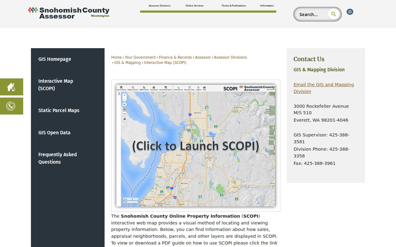
The official guidance is especially useful when a map selection returns shared-interest or multiple-parcel information instead of one simple tax lot.
SCOPI also carries appraisal-neighborhood, aerial, and recent-sales layers. Its 2024 urban aerial imagery was captured from March 31 through May 31. The current recent-sales layer covers January 1, 2024 forward and excludes examples such as non-market or multi-parcel sales. Those dates give a block study context, not proof of who occupied a building.
Check Mountlake Terrace Neighbor Parcels
The SCOPI label “Multiple Parcels” is a warning against a one-address, one-owner assumption. Condominiums, shared interests, or linked tax records may return more than one parcel ID. Capture every associated ID, then compare the legal description and situs before drawing a map relation. A similar number or nearby polygon is not enough to merge two records.
- Parcel
- A tract or unit identified for assessment; it may not match one visible building.
- Plat
- A recorded map that lays out lots, roads, and other divisions.
- Situs address
- The physical address of the parcel, distinct from the taxpayer's mailing address.
- Shared interest
- A property interest linked with other parcels rather than a stand-alone lot.
Note: A nearby polygon shows a geographic relationship, while its owner field states a record role and never guarantees current occupancy.
Six Mountlake Terrace Neighbor Areas
The city's Community Livability Element identifies six conceptual planning subareas: Town Center, Gateway, Melody Hill, Cascade View, Cedar Terrace, and Lake Ballinger. The official subareas map helps place a block in city planning context. These labels are not mailing addresses, ZIP boundaries, plats, or homeowner-association lines.
City descriptions use approximate freeway and arterial references for places such as Melody Hill and Cascade View. Preserve that qualifier. A parcel map supplies the lot boundary; the subarea map supplies broad planning geography. Together they can explain why two nearby properties appear in the same civic plan without implying that the people tied to them belong to the same private group.
Map Mountlake Terrace Neighbors Outward
Use a small, repeatable radius. Start at one address, confirm its parcel, and move only to lots that touch it or face it across the road. This makes the meaning of “neighbors” clear and avoids turning a whole named street into a targetable list. Preserve source dates and roles as each parcel is checked.
- Enter the known street address in Assessor Property Search or locate it on SCOPI.
- Record the parcel ID, situs, legal description, and map date before moving outward.
- Click each adjoining or facing parcel and record only its public owner role and source date.
- Check eTRAKiT for public permit context, while keeping applicants distinct from occupants.
For a full road rather than the immediate block, shift to the Mountlake Terrace street directory. That process follows the broader address and deed chain without stretching this neighbor method past its useful scope.
Mountlake Terrace Neighbor Permit Records
The city's eTRAKiT property search is keyed by address or parcel. Its result tabs can include Parcel, Owner, Restrictions, Land Use, Building, Legal Description, and Inspections. Permit and inspection entries can explain visible work, a land-use question, or a recent public project near the block. The applicant may be an owner, contractor, designer, or other agent, so the name must stay attached to that role.
Open the Mountlake Terrace parcel search screen to choose a field, operator, and value.
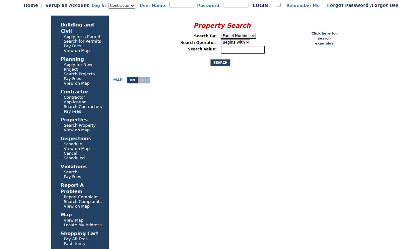
The tabs shown by the city portal keep parcel facts, legal descriptions, buildings, and inspections in distinct record categories.
If the needed file is absent, use the city public-records process. Ask for existing permit, inspection, plan-review, or final-approval records by address or parcel and exact date range. The city accepts portal, mail, email, in-person, and phone requests; it does not have to create a neighbor list.
Mountlake Terrace Neighbor HOA Labels
The Mountlake Terrace parks plan names Walnut Grove HOA Park, Atworth Commons HOA Park, Mint Grove HOA Park, Sunset Landing HOA Park, and Creekside Meadows HOA Park. These place names may help identify a subdivision or explain a nearby parcel label. They do not establish current association membership, resident names, or private contact details. Research did not locate an official city-maintained neighborhood association directory or current contact roster.
That gap matters when researching Mountlake Terrace neighbors. A park name may survive after a development changes, and a planning term may be broader than the subdivision shown on a plat. Check the plat and parcel first. If a civic group publishes a current public contact, use it only to ask about shared events or public meetings. Do not seek a private member list. The absence of a city roster is not evidence that no group exists; it means the available official sources do not support publishing one.
| Local source | Safe block use | What it cannot prove |
|---|---|---|
| Planning subarea map | Broad city context | Association boundary |
| Parks plan HOA name | Subdivision or place clue | Membership or household list |
| Parcel plat | Recorded lot layout | Current occupants |
| Permit file | Dated work at an address | Applicant's residence |
The Mountlake Terrace Library offers computers, scanning, and licensed databases when historical neighborhood research needs a local access point. The regional Northwest Room holds deeper directory and house-history resources, but each old entry must retain its printed year.
Historical context should remain broad. Search newspapers and city archives by a street, park, or planning-area name, then narrow the date. This can uncover a road project, subdivision notice, or civic event without centering the search on a living person. When a directory page is needed, transcribe its publisher, year, address, printed role, and abbreviation key. Never carry an old household name forward as if it identifies today's neighbors.
Mountlake Terrace Neighbor Record Types
Official sources expose their custodian, record type, and access rules. Commercial neighbor tools may blend old directories, marketing files, and recycled public data without showing when a fact changed. That can make them fast but hard to verify. Do not treat a commercial profile as proof, and do not publish a list of names around an address.
| Source type | Strength | Limit |
|---|---|---|
| County parcel or city permit record | Named custodian, date and defined role | Owner or applicant is not an occupant |
| Planning map or plat | Official geographic context | No household information |
| Historical directory | Dated printed address relation | Not current |
| Commercial neighbor profile | May gather leads quickly | Source dates and corrections may be unclear |
For every useful result, save the URL, custodian, query, inspection date, record date, role, and confidence. That small ledger makes later corrections possible.
Protect Mountlake Terrace Neighbors
Washington's Address Confidentiality Program gives qualifying survivors and other protected people a substitute mailing address while keeping the actual address confidential. Courts and other agencies may also seal or redact records. If a parcel or file points to a substitute or protected address, stop. Never combine another source in an effort to uncover the true location.
VoteWA is a registrant's self-lookup that requires first name, last name, and date of birth. It cannot be searched as a Mountlake Terrace neighbor roll. Voter data, DMV records, utility accounts, signatures, birth dates, health details, victim information, and unpublished addresses do not belong in a block file. Keep geographic and civic facts while leaving private people out.
Lawful use. Research about Mountlake Terrace neighbors must remain personal and lawful. Never use it to watch, track, harass, threaten, or intimidate anyone.